A contractor on George Street hit grey silty sand at 800 mm depth. The material looked clean. Site supervisor assumed free-draining granular fill. Three months later stormwater ponded against the foundation wall. The fines content was 28%. That misclassification cost the developer six figures in retrofit drainage. Grain size analysis in Dunedin is not a tick-box exercise. The city sits on a complex mix of loess-colluvium blankets over weathered schist bedrock. Volcanic-derived soils from the Miocene Dunedin Volcanic Complex create local pockets of clay-rich material that behave nothing like the gravels found two streets away. Getting the full distribution curve from coarse gravel down to clay fraction requires paired sieve and hydrometer testing. We run both methods on every sample because the Otago ground profile rarely gives you what you expect from a visual log alone. The lab follows NZGS guidelines and NZS 4402/D7928 protocols for particle size distribution. When the hydrometer curve shows more than 15% passing 0.075 mm, the drainage and liquefaction assumptions change completely.
A sieve test without hydrometer analysis gives you half the curve. The missing half is where the fines content sits. In Dunedin loess, that number decides drainage performance and liquefaction susceptibility.
Methodology applied in Dunedin
Local geotechnical conditions in Dunedin
The most common mistake we see on Dunedin sites is classifying a soil based on sieve-only data and missing a problematic fines tail. A silty sand with 18% fines looks like a well-graded sand on a sieve curve. The hydrometer reveals the silt plateau. That soil will not drain freely. Put a retaining wall drainage layer against it without a filter fabric, and fines migrate into the drainage metal within one wet season. The wall saturates. Hydrostatic pressure builds behind the stem. Wall rotation follows. This failure mode has cost Otago developers tens of thousands in remedial works. Another risk comes from liquefaction screening. The simplified procedure in the MBIE/NZGS guidance uses fines content as a direct input to the cyclic resistance ratio correction. If the laboratory reports only the sand fraction from sieves, the engineer applies the wrong fines correction factor. The liquefaction assessment becomes non-conservative. On the Dunedin flat near South Dunedin, where reclaimed estuarine sediments sit at shallow depth, that error translates directly into under-designed foundations. The full grain size distribution is the cheapest insurance you can buy against a geotechnical misdiagnosis.
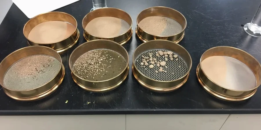
Our services
We provide two levels of grain size analysis depending on the project requirement. Both run through our IANZ-accredited Dunedin laboratory with standard turnaround of five working days.
Combined sieve and hydrometer (full distribution)
Complete particle size distribution from 75 mm down to the clay fraction. Includes semi-log grading chart, D-values (D10 through D85), coefficient of uniformity Cu, coefficient of curvature Cc, and NZGS group symbol. Required for all liquefaction screening, drainage design, and geotechnical investigation reports where fines content exceeds 12%. Report includes tabulated percentages of gravel, sand, silt, and clay.
Sieve-only analysis (coarse fraction)
Sieve analysis from 75 mm down to 75 µm suitable for clean granular soils with visually negligible fines. Provides grading curve for the sand and gravel fractions. Suitable for aggregate quality checks, filter media specification, and preliminary site investigations where the material is clearly free-draining. If the material contains visible fines during logging, we upgrade to the combined method automatically.
Common questions
How much material is needed for a combined sieve and hydrometer test in Dunedin?
We require 500 grams of material passing the 2 mm sieve for the hydrometer portion, plus additional bulk sample for the sieve analysis. For gravelly soils common on the Taieri Plain, we request around 5 kg to ensure representative coarse fraction grading. For silty loess from the hill suburbs, 1 kg is usually sufficient. Contact the lab if the material contains cobbles, as we may need larger sample masses to meet NZS 4402 minimum mass requirements.
What is the cost of grain size analysis in Dunedin?
Full combined sieve and hydrometer analysis ranges from NZ$180 to NZ$300 per sample depending on the number of size fractions and whether Atterberg limits are added. Sieve-only analysis starts at the lower end. Rush turnaround within 48 hours carries a surcharge. Volume discounts apply for projects with more than ten samples.
How long does the hydrometer test take to complete?
The hydrometer sedimentation phase requires readings over a minimum 24-hour period per NZS 4402. Including sample preparation, dispersion, and calculation, the combined sieve and hydrometer analysis has a standard turnaround of five working days. We can expedite to 48 hours for urgent projects where preliminary results are needed for foundation design decisions.
Why do I need hydrometer analysis if the soil looks sandy?
Visual classification consistently underestimates fines content. A soil that appears sandy to the eye can easily contain 15 to 25% silt and clay. That fines fraction controls drainage behavior, frost susceptibility, and liquefaction resistance. The NZGS field classification guideline itself states that hydrometer testing is required whenever fine-grained material is visible. On Dunedin hillside sites, loess-derived soils frequently surprise contractors with fines contents above 20% despite a sandy field texture. More info.